
Page 4 - Lambert Wackers
P. 4
Fort Willem I, in Middle Java, was a railroad station that was an important transshipment
point. Transshipment means that travelers had to change trains because the gauge of the
railroad tracks changed to a different width. I can imagine it was a place where engineers
found enough technical problems to solve. Marjan and I visited the Ambarawa Railroad
Station Museum, Willem I, in 2015, as described in Part 4, pg. 62.
Lambert was on duty at Fort Willem I from 1886 to 1888. Subsequently, he was transferred
to the Corps of Engineers on the Molukkan spice islands, Ambon and Ternate. Newspaper
messages provided no information about Lambert’s tasks or responsibilities on the remote
islands. He may have received more specific training in triangulation.
Triangulation for mapping Sumatra
On April 30, 1890, there was an announcement that Mr. L. Wackers boarded the s.s. Sindore
in Surabaja to go to Semarang and Batavia. In May 1890, he arrived in Telok-Betong, on the
south tip of Sumatra. He then continued his journey to join the Triangulation Brigade of
the KNIL Topographical Service in Padang on Sumatra’s west coast.
The reader should excuse me that I had no idea what triangulation work involved.
I found a useful description in a relatively recent article by L. Prawirodirdjo, Y Bock, and JF
Genrich of the Scripps Institution of Oceanography at UC San Diego in the Journal of
Geophysical Research, "One Century of tectonic deformation along the Sumatran fault
from triangulation and Global Positioning System surveys." 2000; vol. 105: pg. 28,343-
28,361. Although the main research article is about tectonic deformation, it described the
triangulation survey as it was done more than 100 years ago by the KNIL Triangulation
Brigade. I slightly reworded the text for better understanding,
Triangulation Survey
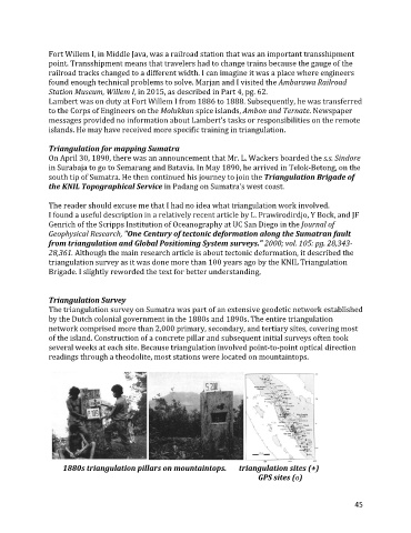
The triangulation survey on Sumatra was part of an extensive geodetic network established
by the Dutch colonial government in the 1880s and 1890s. The entire triangulation
network comprised more than 2,000 primary, secondary, and tertiary sites, covering most
of the island. Construction of a concrete pillar and subsequent initial surveys often took
several weeks at each site. Because triangulation involved point-to-point optical direction
readings through a theodolite, most stations were located on mountaintops.
1880s triangulation pillars on mountaintops. triangulation sites (+)
GPS sites (o)
45